Many people
hold the belief that the narration in the Book of Genesis about a
Paradise on earth is an allegorical myth. However, the
historical and geographical evidence given to us by the Holy
Bible has not only proven to be genuine, but it can also be used
as an important historical source for Mesopotamia’s endmost
past: 5500 BC.
This study
researches the time and place pertaining to Adam, by means of certain
information provided for us in Genesis regarding the cradle
of Adam’s people.
The four rivers of Eden
In order to
find the location of Paradise, we resort to a certain important
geographical element found in the Holy Bible, which is described
in Genesis 2:10-14:
10And
a river
comes forth out of Eden
to water the garden;
and from thence it parts into four heads
(main streams).
11The name of the first is
Phison:
this is the one that encompasses the entire land of
Havilah,
where there is gold;
12And the gold of that land is
good: there is bdellium
and the green stone
(onyx).
13And the name of the second
river is
Gihón:
this is the one that compasses the entire land of Ethiopia
("Kush"
according to the Hebrew text).
14And the name of the third
river is
Tigris
(Hiddekel):
this one proceeds before the Assyrians.
And the fourth river is
Euphrates.
Tigris and
Euphrates are the well-known rivers that spring from the
highlands of Armenia and pour into the Persian Gulf. Therefore
we know that the Garden of Eden (Paradise) was located somewhere
around Mesopotamia. But in which part of Mesopotamia?
Many have
attempted to locate it in the highlands of Armenia, where the
Tigris and the Euphrates spring from. The reason for this is the
aforementioned words of Genesis: “And
a river
comes forth out of Eden
to water the garden”.
So, they looked for that river in the highlands that the Tigris
and the Euphrates sprang from. However, a more careful reading
reveals that the verse is telling us something else.
The verse
does not say that the river flowed out from Paradise, in
order for us to be looking for it in the rivers’ sources. It
says that the river flowed forth
from Eden, which
was
the greater geographical area around the "garden"
(Paradise). Hence, we cannot look for Paradise at the rivers’
sources, but at the point where the four ancient rivers
intersect. And the region that has four rivers flowing
through it must be an incredibly fertile and wet land, a
paradise; something that is unlikely to occur in any mountainous
headwaters of a river.
Gihon and the Cassites
Although
the Tigris and the Euphrates rivers were known, Gihon was a
problem, since Genesis writes that “it was the one that
compasses the entire land of Ethiopia”
("Kush"
according to the Hebrew text).
Of course we
cannot possibly be referring to Ethiopia. Here, the Hebrew text
proves to be more correct, as instead of “Ethiopia” it mentions
the land “Kush”, the land of the
Kushites
(1) or
Cassites.
During the
Hellenistic era, the Cassites and the location of their country
was unknown and the attempts by interpreters of those times to
reconcile the Genesis narration regarding Eden with the
geography of the world that was familiar to them led to errors.
Thus, without any proof, they related the Gihon to the River
Nile and the land of Kush to the land of Nubia, from where the
Nile flows and to which river the Hellenistic Jews had given the
name ‘Kush’.
The Cassites
were ‘rediscovered’ only in the last century, in references
about them that were found in ancient cuneiform writing.
In Moses'
time, ‘Kush’ was a river that joined the Euphrates a few miles
South of the point that the Tigris River joins it, near Abadan.
Today this
river is called Karun, and it
springs from the mountains of Iran, east of the Persian Gulf,
into which the Tigris, the Euphrates and the Karun rivers all
empty their waters. Gihon flowed from the Land of Kush, namely
outside the land of the ancient Cassites who were in the
region between the mountains of Iran and the land of Assyria
(between the Tigris and the Euphrates), exactly as Genesis says.
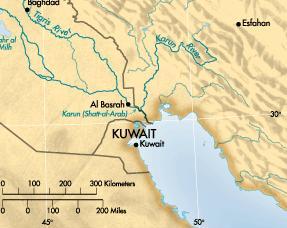
A modern map, showing the three of the four
rivers (Euphrates-Tigris-Karun)
The Cassites
were originally a nomadic, pastoral people, with their
beginnings in the Near East - as part of the expansion of the
Indo-European peoples beyond Turkey, into Persia, and finally,
into India. During the fall of the Babylonian empire, they had
established an empire of their own that lasted four centuries.
After the end of the Cassitic period, their name was forgotten.
The lost river Phison
Phison has not
been ‘flowing’ for the last 4000 years. Today, it is only a dry
valley called Wadi al-Batin whose source is located in
the most auriferous area of Saudi Arabia, just North of Medina.
However during the wet season (prior to 3500 b.C.), it used to
spring from the Arabian Peninsula and would join the Euphrates
at approximately the same point as Gihon (Karun). Shortly
after that time - perhaps around 2000 BC - it dried up.
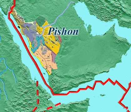
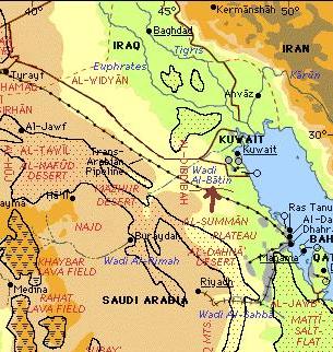
(The red lines are a
seismological reference) Arrow on modern map of Wadi Al Batin
Although its
existence has been preserved as a memory, nevertheless its
location was no longer known when the Genesis narration was
recorded.
Recently
however, this dried-up ‘riverbed’ was discovered by means of a
satellite photo by Farouk El-Baz of Boston University. He
concluded that the river initially flowed for more than 650
miles from the Hejaz mountains (in Saudi Arabia) to Kuwait,
where it joined the Euphrates river. The story of this discovery
was published by James Souer (1996: 52-57, 64) in the Periodical
of Biblical Archaeology.
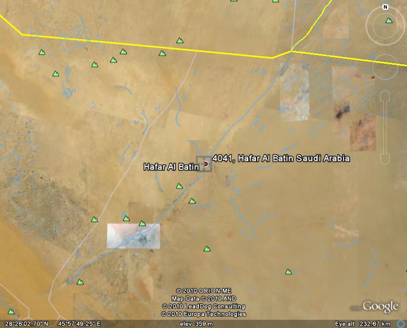
Satellite image of the town of Hafar Al-Batin,
situated on the Wadi (river) Al Batin
The point
where this river used to channel its waters was already known to
archaeologist Leonard Woolley, who, in his book “The excavations
at Ur”, described how this river, together with the other three,
had created the valley of Mesopotamia with their illuviations.
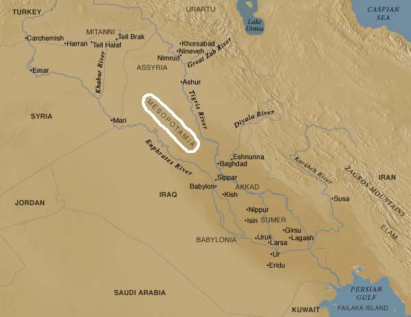
The location of Paradise
From the above
description of the four rivers mentioned in Genesis one can
deduce that the Biblical location of the Paradise of Eden
corresponds to the region of ancient Sumeria. Thus, it can be
acknowledged as the largest flooded plain of the Euphrates,
south of the ancient cities of Sumeria.
According to
Sumerian tradition, the oldest of all Sumerian nation-states
and traditional homeland of Adapa (Adam),
was the city of
Eridu, which was discovered, just like the Sumerian cities
of Ur and Erech (Uruq), on the banks of the river Euphrates.
(The ruins of these cities are situated approximately 400 miles
from the point where the Euphrates River empties into the
Persian Gulf.) This was the first region that was formed from
the illuviations of the four rivers. Eridu started out as a
simple settlement, was built by its first inhabitants around
5400 b.C. and continued to be inhabited, at least until 3600
BC.
The region was
originally flooded with water. However, it gradually began to
resurface. Eridu, where Adam and his descendants had settled
after being expelled from Paradise, was obviously one of the
first regions.
Over time, the
progressive increase of alluvial river mud shifted the shoreline
of the South much further out. Thus, the estuaries where the
rivers emptied their waters had changed, which as a result, gave
rise to the ensuing confusion about the location of Paradise.
The
era of Adam
The
aforementioned dating of Eridu is extremely important for the
confirmation of the narration in Genesis as well as for the
choice of text that is to be accepted.
As is well
known, the most valid texts of the Old Testament today are the
Hebrew and the Septuagint (which is
far more ancient than the Hebrew
text). However, on the matter of chronologies in the book of
Genesis, the dates that we are given differ between them by 1500
years. Thus, the Hebrew text places Adam around
4000 b.C.
while the Septuagint places him around
5500 b.C.!
As we have
seen above, the year 5500 b.C. is exceptionally close to
the chronology established by the archeologists for the
beginning of the inhabitation of the first city of Sumeria: Eridu (5400
b.C.). So, while Adam was placed in Paradise in 5500 b.C.,
the first settlement by his descendants is dated from 5400 b.C.,
namely 100 years later. This is the best proof of the veracity
of the chronological charts in Genesis! We could of course
mention other elements here - for example, that Cain was a
farmer and Abel was a shepherd - which has been confirmed by
archaeologists' excavations on the activities of the area’s
first settlers.
Thus, even
though the Hebrew text has often proved to be more reliable in
its rendition of certain words, it has however proved to be less
trustworthy than the Septuagint in the matter of dates. (Further
proof of the validity of the Septuagint text versus the Hebrew
text can be found in the dating of Noah's Flood etc.).
From the
above, it appears that we can trust the Holy Bible; not as an
allegorical record, but as a faithful portrayal of historical
events which can to this day influence our faith and our
eternal future.
---------------------------------------------------------------------
Bibliography:
Souer, James,
1996 “The River Runs Dry” Periodical of Biblical Archaeology,
Vol.22, No.4, (July/August) pp. 52-57, 64.


